|
|
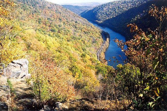 Nearly One Thousand Feet Above the Youghiogheny River |
Collection
Location
Type
Season
Camera Info
Nikon N90 (Film)
Published
November 9, 2002
|
Description
Featured is a November 3, 2002 view from Lookout Point, which is about three miles southeast of South Connellsville, PA, and only accessible via rough dirt roads. The river below resides at about 980 feet above sea level, and the point this photograph was taken is nearly 2000 feet. That is a remarkable drop in elevation over such a short distance, as this is the point where the Youghiogheny River cuts through Chestnut Ridge. While one thousand feet in elevation doesn't sound like much, I've been at this spot with more than a foot of snow on the ground � while the elevations surrounding the river had no snow at all. The most distant hill in the picture is actually Laurel Ridge, roughly 8-10 miles to the east, and now bearing a line of windmills. A very steep cliff makes Lookout Point's impressive view possible - the cliff's rock ledge can be seen in this photograph.
Subjects featured: Chestnut Ridge; Casparis Lookout Point; Casparis; Youghiogheny River; Laurel Ridge;
Subjects featured: Chestnut Ridge; Casparis Lookout Point; Casparis; Youghiogheny River; Laurel Ridge;
Commission Michael to photograph the essence of your place, town, area, resort, or park
in its best possible light. Learn More >